The United States isn’t just a country; it’s a collection of economies and populations that rival entire nations. If the “United” part of the name suddenly dissolved and the states found themselves in a hypothetical, isolated conflict, only a few have the “Full Package”—the combination of geography, industry, and sheer firepower—to hold their own.
Here is a breakdown of the heavy hitters that could realistically sustain a solo war effort.
1. Texas: The Fortress Republic
Texas is the most obvious candidate for a reason. It is the only state that could arguably function as a fully sovereign nation tomorrow morning without breaking a sweat.
• Energy Independence: Texas produces more energy than any other state. With its own power grid (ERCOT) and massive oil reserves, it could keep the tanks rolling and the lights on long after others ran dry.
• Military Infrastructure: Home to Fort Cavazos (formerly Fort Hood) and Joint Base San Antonio, Texas houses a massive chunk of the U.S. Army’s armored capabilities and the Air Force’s training wings.
• Geography: It has a coastline for international trade (or blockades) and enough “depth” in its territory to make a ground invasion a logistical nightmare for any neighbor.
2. California: The Economic Superpower
If California were its own country, it would have the 5th largest economy in the world. In a war of attrition, money and tech win.
• The Tech Edge: With Silicon Valley, California controls the software and drone tech that defines modern warfare.
• Naval Dominance: San Diego is the heart of the Pacific Fleet. Any state trying to fight California would have to contend with a massive naval presence and sophisticated surveillance systems.
• Agricultural Breadbasket: Unlike other states that might have guns but no butter, California’s Central Valley ensures its population and military stay fed.
3. Virginia: The Nerve Center
While smaller in landmass, Virginia punches way above its weight class because it is essentially the “brain” of the American military-industrial complex.
• The Atlantic Gateway: Norfolk is the largest naval base in the world. Virginia doesn’t just have a navy; it has the shipyards (Newport News) to build and repair nuclear-powered aircraft carriers.
• Intelligence & Command: With the Pentagon, CIA, and various “alphabet soup” agencies headquartered there, Virginia would likely have the best “eyes and ears” in any conflict.
4. Hawaii: The Unreachable Island
Hawaii wouldn’t win by invading the mainland; it would win by being impossible to reach.
• Strategic Distance: To attack Hawaii, another state would need a blue-water navy and a massive logistical tail. Most states simply don’t have the reach.
• The Pacific Shield: As the headquarters of INDOPACOM, Hawaii is one of the most densely fortified places on Earth, packed with missile defense systems and elite submarine fleets.
The Verdict
If the “State Wars” began tomorrow, Texas and California are the only two with the industrial base, energy, and food supplies to sustain a long-term, multi-front solo campaign. Everyone else would likely be forced into regional alliances just to keep the lights on.
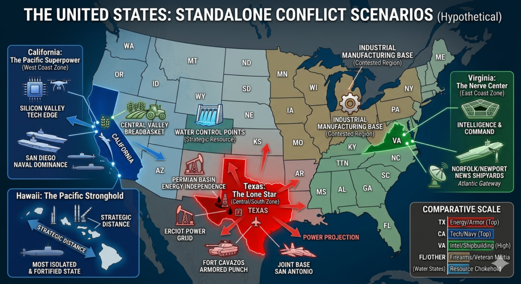
The Tactical Map: 202X Scenario
The map visually segments the country, not by current state lines, but by potential “spheres of influence” and major industrial/military clusters. This layout emphasizes how smaller or less-industrialized states might be forced into regional blocs.
• The Lone Star Dominion: Texas stands out clearly. Its map highlights its direct control over critical infrastructure: major oil fields in the Permian Basin, the independent ERCOT power grid, and dominant military hubs like Fort Cavazos and Joint Base San Antonio. The geography offers deep strategic defense, making it the premier fortress republic.
• The Pacific Coalition: California dominates this zone, controlling not just immense population centers but also the global “mind share” of Silicon Valley and the unparalleled logistics of the Central Valley breadbasket. The inclusion of San Diego and the Channel Islands highlights its naval supremacy. Note how Nevada and Arizona might be depicted as dependent or annexed territories to secure resources.
• The Atlantic Bastion: Virginia, though small, is depicted as the crucial intelligence and naval repair “capital.” This region maps the concentration of the Pentagon, Norfolk Naval Base (the largest on Earth), and the shipbuilding capabilities of Newport News. It controls the Eastern access point, a critical strategic edge.
• Island Stronghold: Hawaii is shown as geographically isolated and heavily fortified. The visualization emphasizes its distance as a core defensive advantage. A call-out shows how INDOPACOM’s massive missile defense networks and nuclear-powered submarine fleets create an almost impenetrable perimeter.
Analyzing the Zones
The visualization reinforces the blog’s analysis that most of the 50 states simply don’t have the complete “Full Package” for modern, state-level warfare. Looking at the map, we see how other vital resources—like the water sources in the Mountain West or the manufacturing cores in the Great Lakes region—become immediate strategic objectives that small states could not defend alone.
In this scenario, true independence means possessing energy, food, manufacturing, and a world-class military, which is why Texas and California remain the undeniable heavyweights.